GARMIN GPSMAP 1643xsv Multifunction Display with US+Canada Garmin Navionics+ Charts 010-02919-03
Mfg # 010-02919-03
Model # 20979506
This item qualifies for FREE Shipping
*Signature for delivery is Required
Embrace connectivity, clarity and control at the helm with the GPSMAP® 16x3 chartplotter. This advanced MFD supports the same easy-to-use features from our GPSMAP x3 series but with a bigger 16” HD IPS touchscreen display.
Anglers can enjoy options such as built-in support for the full line of LiveScope™ and Panoptix™ sonars, ClearVü™ and SideVü™ scanning sonars, and Garmin CHIRP traditional sonar (transducer required; sold separately). Once you find the fish, stay on them with Force® trolling motor support and integration.
Enjoy simple navigation with support for Garmin Navionics+™ charts with Auto Guidance+™ technology, or upgrade to premium charts from Garmin Navionics Vision+™ cartography for high-resolution relief shading and more (Auto Guidance+ is for planning purposes only and does not replace safe navigation operations).
Connect multiple chartplotters, radars, cameras and more with seamless vessel integration on the Garmin Marine Network. Sailors at the helm can enjoy premium sailing features, such as sailing polars, and see laylines, race start line guidance and more with Garmin SailAssist™ features.
Features:
High-resolution 16” touchscreen, IPS display offers sunlight readability and visibility from any angle, even with polarized glasses
Experience fast and responsive high-speed processing power of the GPSMAP® x3 series chartplotters
Support for mapping includes Garmin Navionics+™ charts with built-in Auto Guidance+™ technology and Garmin Navionics Vision+™ cartography with premium features, such as high-resolution relief shading (Auto Guidance+ is for planning purposes only and does not replace safe navigation operations).
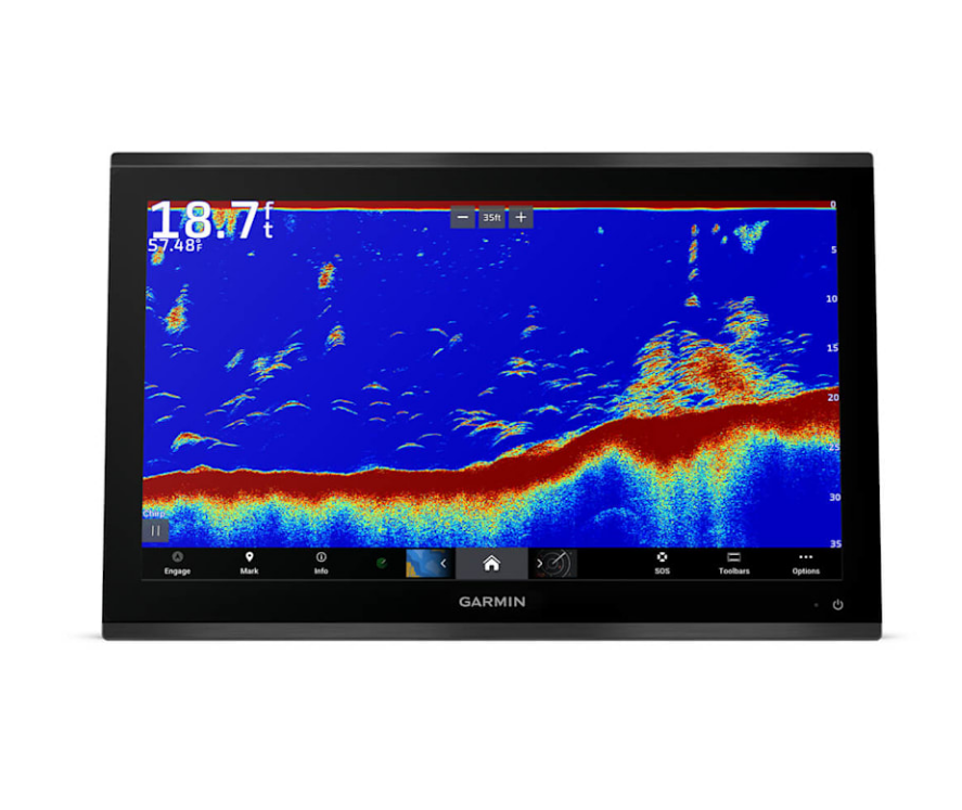
Ultra High-Definition Scanning Sonar: Get built-in Ultra High-Definition SideVü™ and ClearVü™ scanning sonars with vivid, high-contrast color palettes to help distinguish fish from structure. The GPSMAP X3 chartplotter series also supports 1 kW traditional sonar capabilities.
Live Sonar Support: Pair with Panoptix™ or LiveScope™ easy-to-interpret live sonar (transducer required, sold separately) to see all around your boat in real time.
Faster, Sharper, Smarter: With its added processing power and slimline design featuring edge-to-edge glass, it’s easy to fit this plotter in a wider range of dash configurations.
Bright and Clear Optics: High-resolution IPS displays for 9”, 12” or 16” chartplotters offer improved sunlight readability and visibility from any angle.
Preloaded Mapping: Experience unparalleled coverage and detail with built-in Garmin Navionics+™ integrated coastal and inland mapping that includes Auto Guidance+™ technology2 and a 1-year subscription for downloadable daily updates and more on select chartplotters.
Power-Pole® Shallow Water Anchor: By networking your select Garmin chartplotters with a Force® trolling motor and your compatible Power-Pole shallow water anchoring system, you can access advanced boat control features3 from your plotter, including smart anchor auto-deployment, smart anchor jog, auto stow, anchor drag detection and end-of-route anchoring. Spend more time fishing, less time positioning.
Trolling Motor Integration: Get support and integration for your Force trolling motor (sold separately) to gain complete control while you fish.
Charge Integration from Power-Pole: Your CHARGE Marine Power Manager from Power-Pole integrates with compatible Garmin chartplotters to help keep your battery power going longer and stronger on the water. You’re able to charge batteries on the run, monitor power use, select where power is allocated, control emergency starts and even transfer power between battery banks — all from your chartplotter display. (Integration of these features requires purchase of a C-Monster® GATEWAY through Power-Pole)
Garmin SailAssist™ Sailing Features: View laylines, race start line guidance, enhanced wind rose, heading and course-over-ground lines, true wind data fields and tide/current/time slider, wind angle, set and drift, wind speed and more.
Sailing Polars: Use the polar table to see key data, including how fast you should go at a certain wind angle and speed — so you know whether you need to adjust sail trim.
Garmin Marine Network: If you have multiple compatible Garmin devices on your boat, you can share information — such as maps, user data, radar and IP camera video — among them.
NMEA 2000® and NMEA 0183 Networks: Connect to compatible autopilots, digital switching, weather, the Fusion audio system, media, VHF, AIS and more from one screen.
ActiveCaptain® APP: Built-in Wi-Fi® connectivity pairs with the free all-in-one mobile app for access to the OneChart™ feature, smart notifications, software updates, Helm app, Garmin Quickdraw™ Community data and more. (Requires ActiveCaptain app on your compatible smartphone paired to your chartplotter)
Integrated ANT® Technology: Connect with some of your favorite devices, such as quatix® marine watches, gWind™ Wireless 2 transducers, GNX™ Wind marine instruments and wireless remote controls.
Engine Connectivity: You can connect your chartplotter to different engines, including select Yamaha® engines.
OneHelm Feature: This feature brings together all the operations and capabilities of select third-party devices, such as EmpirBus™ digital switching, on one screen.
Send inReach® Device Messages: Pair your inReach satellite communicator4 to your chartplotter, and type custom messages by using your MFD’s on-screen keyboard. Access your contact list, or enter an email, inReach address or phone number. You can also group messages by conversation for a texting-like experience. (Active satellite subscription required)
In the Box:
GPSMAP 1643xsv chart-plotter
microSD™ card preinstalled
8-pin transducer to 12-pin sounder adapter cable
Power cable
Flush mount kit with gasket
Protective cover
Trim piece snap covers
Backbone/drop cable (2 meters) and T-connector for the NMEA 2000® network
Documentation
Warranty: Manufacturer
Details:
Card Type: 2 microSD cards
Charts: US and Canada Navionics+
Compatibility: NMEA 2000, 0183,Bluetooth,12-Pin Transducer, ANT+,USB
Dimensions15.1” x 10.3” x 3.0” (38.4 x 26.2 x 7.6 cm)
Display Size: 16 Inches
Display Type: FHD, IPS
GPS: Internal GPS Antenna
Mount Type: Flush, Bail, Flat
Resolution: 1920 x 1080
Sonar: ClearVu 260/455/800/1000/1200 kHz, SideVu 260/455/800/1000/1200 kHz
Transducer Included: No
Voltage: 10 to 32 Vdc
Waterproof: IPX7
Weight: 9.7 lbs. (4.4 kg)
See all Garmin Accessories and Compatible Devices (sold separately) here
Suncoast Marine and Auto is a Trusted Authorized Dealer
California: Cancer and Reproductive Harm – www.P65Warnings.ca.gov
Mfg # 010-02919-03
Model # 20979506
This item qualifies for FREE Shipping
*Signature for delivery is Required
Embrace connectivity, clarity and control at the helm with the GPSMAP® 16x3 chartplotter. This advanced MFD supports the same easy-to-use features from our GPSMAP x3 series but with a bigger 16” HD IPS touchscreen display.
Anglers can enjoy options such as built-in support for the full line of LiveScope™ and Panoptix™ sonars, ClearVü™ and SideVü™ scanning sonars, and Garmin CHIRP traditional sonar (transducer required; sold separately). Once you find the fish, stay on them with Force® trolling motor support and integration.
Enjoy simple navigation with support for Garmin Navionics+™ charts with Auto Guidance+™ technology, or upgrade to premium charts from Garmin Navionics Vision+™ cartography for high-resolution relief shading and more (Auto Guidance+ is for planning purposes only and does not replace safe navigation operations).
Connect multiple chartplotters, radars, cameras and more with seamless vessel integration on the Garmin Marine Network. Sailors at the helm can enjoy premium sailing features, such as sailing polars, and see laylines, race start line guidance and more with Garmin SailAssist™ features.
Features:
High-resolution 16” touchscreen, IPS display offers sunlight readability and visibility from any angle, even with polarized glasses
Experience fast and responsive high-speed processing power of the GPSMAP® x3 series chartplotters
Support for mapping includes Garmin Navionics+™ charts with built-in Auto Guidance+™ technology and Garmin Navionics Vision+™ cartography with premium features, such as high-resolution relief shading (Auto Guidance+ is for planning purposes only and does not replace safe navigation operations).
Ultra High-Definition Scanning Sonar: Get built-in Ultra High-Definition SideVü™ and ClearVü™ scanning sonars with vivid, high-contrast color palettes to help distinguish fish from structure. The GPSMAP X3 chartplotter series also supports 1 kW traditional sonar capabilities.
Live Sonar Support: Pair with Panoptix™ or LiveScope™ easy-to-interpret live sonar (transducer required, sold separately) to see all around your boat in real time.
Faster, Sharper, Smarter: With its added processing power and slimline design featuring edge-to-edge glass, it’s easy to fit this plotter in a wider range of dash configurations.
Bright and Clear Optics: High-resolution IPS displays for 9”, 12” or 16” chartplotters offer improved sunlight readability and visibility from any angle.
Preloaded Mapping: Experience unparalleled coverage and detail with built-in Garmin Navionics+™ integrated coastal and inland mapping that includes Auto Guidance+™ technology2 and a 1-year subscription for downloadable daily updates and more on select chartplotters.
Power-Pole® Shallow Water Anchor: By networking your select Garmin chartplotters with a Force® trolling motor and your compatible Power-Pole shallow water anchoring system, you can access advanced boat control features3 from your plotter, including smart anchor auto-deployment, smart anchor jog, auto stow, anchor drag detection and end-of-route anchoring. Spend more time fishing, less time positioning.
Trolling Motor Integration: Get support and integration for your Force trolling motor (sold separately) to gain complete control while you fish.
Charge Integration from Power-Pole: Your CHARGE Marine Power Manager from Power-Pole integrates with compatible Garmin chartplotters to help keep your battery power going longer and stronger on the water. You’re able to charge batteries on the run, monitor power use, select where power is allocated, control emergency starts and even transfer power between battery banks — all from your chartplotter display. (Integration of these features requires purchase of a C-Monster® GATEWAY through Power-Pole)
Garmin SailAssist™ Sailing Features: View laylines, race start line guidance, enhanced wind rose, heading and course-over-ground lines, true wind data fields and tide/current/time slider, wind angle, set and drift, wind speed and more.
Sailing Polars: Use the polar table to see key data, including how fast you should go at a certain wind angle and speed — so you know whether you need to adjust sail trim.
Garmin Marine Network: If you have multiple compatible Garmin devices on your boat, you can share information — such as maps, user data, radar and IP camera video — among them.
NMEA 2000® and NMEA 0183 Networks: Connect to compatible autopilots, digital switching, weather, the Fusion audio system, media, VHF, AIS and more from one screen.
ActiveCaptain® APP: Built-in Wi-Fi® connectivity pairs with the free all-in-one mobile app for access to the OneChart™ feature, smart notifications, software updates, Helm app, Garmin Quickdraw™ Community data and more. (Requires ActiveCaptain app on your compatible smartphone paired to your chartplotter)
Integrated ANT® Technology: Connect with some of your favorite devices, such as quatix® marine watches, gWind™ Wireless 2 transducers, GNX™ Wind marine instruments and wireless remote controls.
Engine Connectivity: You can connect your chartplotter to different engines, including select Yamaha® engines.
OneHelm Feature: This feature brings together all the operations and capabilities of select third-party devices, such as EmpirBus™ digital switching, on one screen.
Send inReach® Device Messages: Pair your inReach satellite communicator4 to your chartplotter, and type custom messages by using your MFD’s on-screen keyboard. Access your contact list, or enter an email, inReach address or phone number. You can also group messages by conversation for a texting-like experience. (Active satellite subscription required)
In the Box:
GPSMAP 1643xsv chart-plotter
microSD™ card preinstalled
8-pin transducer to 12-pin sounder adapter cable
Power cable
Flush mount kit with gasket
Protective cover
Trim piece snap covers
Backbone/drop cable (2 meters) and T-connector for the NMEA 2000® network
Documentation
Warranty: Manufacturer
Details:
Card Type: 2 microSD cards
Charts: US and Canada Navionics+
Compatibility: NMEA 2000, 0183,Bluetooth,12-Pin Transducer, ANT+,USB
Dimensions15.1” x 10.3” x 3.0” (38.4 x 26.2 x 7.6 cm)
Display Size: 16 Inches
Display Type: FHD, IPS
GPS: Internal GPS Antenna
Mount Type: Flush, Bail, Flat
Resolution: 1920 x 1080
Sonar: ClearVu 260/455/800/1000/1200 kHz, SideVu 260/455/800/1000/1200 kHz
Transducer Included: No
Voltage: 10 to 32 Vdc
Waterproof: IPX7
Weight: 9.7 lbs. (4.4 kg)
See all Garmin Accessories and Compatible Devices (sold separately) here
Suncoast Marine and Auto is a Trusted Authorized Dealer
California: Cancer and Reproductive Harm – www.P65Warnings.ca.gov